
Vertical positioning is critical for location intelligence and emergency response in large, dense urban areas. Longitude and latitude alone are not enough to identify a subject’s position in a multi-story skyscraper, underground parking garage, or subway station, for example. Nevertheless, the automatic push of emergency caller location data to Public Safety Answering Point operators today generally uses 2D maps (X- and Y-axis only).
Using a combination of device and mobile networks data, vertical, or 3D, location adds Z-axis information to 2D models to place a caller on a specific floor of a building or subterranean structure. The US Federal Communications Commission (FCC) has led the way in improving emergency services by developing new standards for 3D location, generally requiring vertical accuracy to within 3 meters above or below the handset. In alignment with these requirements, SS8 is engineering lawful intelligence and location-based solutions incorporating a variety of methodologies for achieving 3D positioning accuracy and is actively involved in industry collaborations to advance these capabilities.
The 3D Location Intelligence Imperative
When first responders arrive at an urban site without accurate vertical location information, they may be unable to find emergency callers. The resulting delay can put lives at risk, wasting valuable seconds that could be spent treating critical injuries or diffusing a hostile situation.
A variety of techniques can be used to calculate z-axis position based on information from both handsets and mobile networks. However, solutions must be highly reliable and cover the highest possible portion of the population. They must be widely applicable across the full spectrum of devices, from older feature phones to modern smartphones. They must also be interoperable with all mobile network generations, from 2G to 5G. Because of these mandates, a combination of 3D positioning methodologies is often best
Handset-Based Techniques: Potential and Limitations
While none are fully effective or reliable on their own, and some are not yet technologically mature, the following are the most commonly used handset-based approaches to establishing vertical location :
- Global Positioning System (GPS): GPS is highly-accurate, but the need for a satellite in a specific overhead location and the device’s inability to transmit a signal through building walls makes it unreliable for calculating vertical position.
- Barometric pressure: A growing proportion of new smartphones can determine barometric pressure for vertical positioning, however the data can be affected by weather and building features such as elevator shafts. In addition, older generation devices do not have this capability.
- Wi-Fi networks: Individual Wi-Fi networks visible by a device can provide vertical position information, albeit with lower reliability than mobile network mast position due to a dependency on open source databases of Wi-Fi network locations.
- Bluetooth and other RF Beacons: Dedicated beacons can be deployed to provide indoor vertical location information, but the technology requires significantly more widespread adoption to meet the needs of law enforcement and emergency services.
- Mobile networks: can provide signal angle of arrival and angle of departure information to the network, which can locate devices on the vertical axis, but as with beacons, this technology is not yet pervasive among handsets and networks.
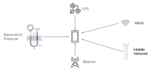
Handset techniques for vertical location intelligence.
Network-Based Techniques: Potential and Limitations
There is some overlap in handset- and network- based vertical location techniques, and like the handset-orientated approaches above, any single network approach is insufficient on its own:
- Mobile networks: Signal strength is highly dependent on penetration into the building and the relative location of the mast, yet this set of techniques will become more valuable with beamforming in 5G networks.
- Bluetooth or other RF Beacons: These can be deployed in large buildings to provide height location but can be costly and must be widespread to provide value.
- Wi-Fi networks are prevalent in large buildings, but to be reliable for vertical location a more rigorous process for comprehensive, accurate network information must be established.
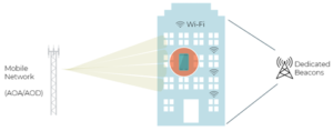
Network techniques for vertical location intelligence.
To realize the full benefit of all the above techniques, the ecosystem must collaborate for further research and adoption. SS8 works closely with device and mobile operating system providers, in addition to law enforcement agencies (LEAs), emergency services, and communication service providers (CSPs), to advance these methodologies and help first responders save lives.
The Path Forward
The breadth of technologies available offers potential for novel data fusion techniques to contribute vertical position information to location intelligence. AI and machine learning are revealing new approaches to assessing the accuracy and reliability of position data from multiple approaches for better overall outcomes. SS8 is continually working to bring all relevant parties to the table to advance these solutions, including PSAP operators, device/OS providers, and network vendors.
Looking ahead, government mandates may play a role in providing common, reliable approaches. Given the significant costs of deploying these solutions, government funding may also be needed. For the sake of accurate vertical location information for emergency response, technological innovation and stakeholder support must combine to replace the 2D techniques and maps prevalent today with vertical, 3D positioning.
About Michael Gebretsadik
 Michael has worked in the telecommunication industry for the better part of two decades, in roles ranging from engineering to product management, and business development. He has been involved with location technology since 2003, when he joined SnapTrack (a Qualcomm subsidiary). Prior to joining SS8 in 2020, Michael was responsible for growing the global Location-Based Services business for Comtech Telecommunications through channel partners and IoT OEMs. You can learn more about Michael on his LinkedIn profile.
About Stuart Walsh
 Stuart Walsh is a consultative technical sales leader with over 25 years of experience helping customers deliver solutions for success. As the leader of the product division at Creativity Software, a wholly owned subsidiary of SS8 Networks, Stuart is passionate about introducing next generation solutions and services to network operators and enterprises and driving business growth. Stuart also has a depth experience in voice and data applications for both Enterprise and Service Provider customers. You can view his LinkedIn profile here.
About SS8 Networks
SS8, a network intelligence company, provides solutions to help customers quickly identify, track, and investigate devices and subjects of interest. SS8 is trusted by six of the largest intelligence agencies, eight of the fourteen largest communications providers and five of the largest systems integrators.